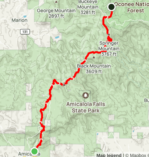
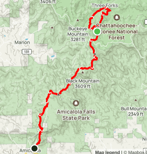
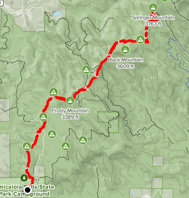
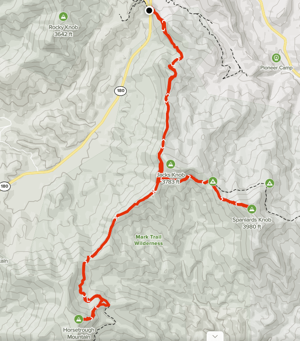
One night backpack from Amicalola Falls

Summary
Distance: 25.7 miles
Elevation gain:5,580 feet
Type: Out and back
Start: Dirt road, passenger car accessible. (map)
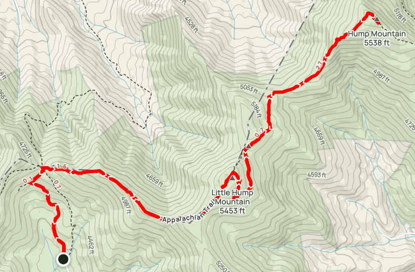
AllTrails Day 1: map 10.3 miles
AllTrails Day 2: map 15.4 miles

It’s thru hiker season on the Appalachian Trail and I always enjoy staying at a shelter on the AT so I can meet and talk to the folks who are just starting their hike northward. This year an overnight stay at a shelter was not a good idea due to norovirus. According to the Georgia Appalachian Trail Club, the virus is very widespread on the trail throughout the Georgia section. To make matters worse, hand sanitizer doesn’t kill the virus, only diligent hand washing will protect you from the awful stomach bug. Of course, running water on the trail is difficult to find, making proper cleanliness all but impossible.

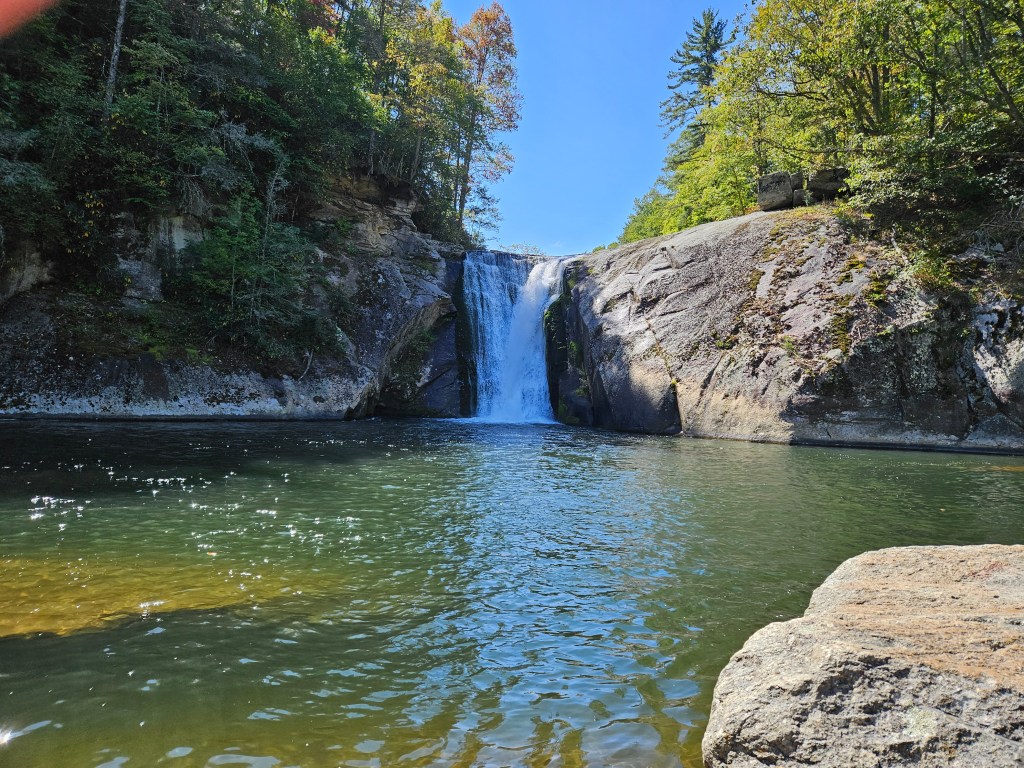
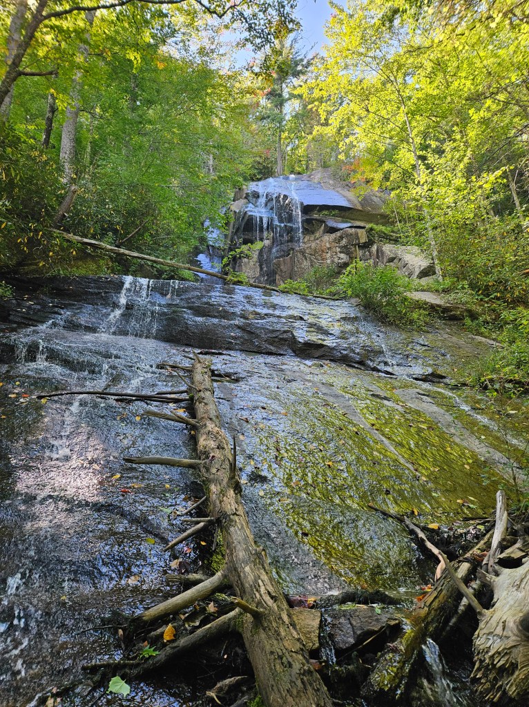
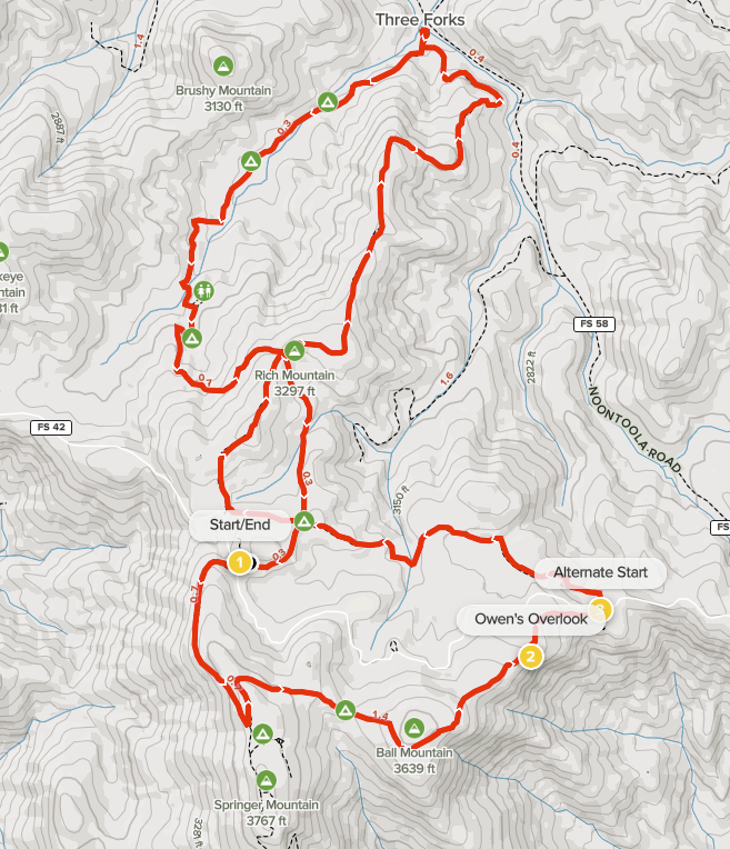
There is a really pretty campsite that I’ve seen before that was a prefect distance for me, so I decided to give that site a try instead of staying at a shelter. The site was great, right next to a small stream and somewhat protected from the strong winds that blew overnight.

Continue reading “One night backpack from Amicalola Falls”

More photos from Roan Mountain trip

On my way to Roan Mountain State Park from visiting my sister in North Carolina, I stopped for a hike to see Elk River Falls and Jones Falls. Elk River Falls is a short walk from a trailhead, while Jones Falls is a few miles away on the Appalachian Trail.

Elk River Falls near Elk Park, North Carolina
Jones Falls on the Appalachian Trail
Continue reading “More photos from Roan Mountain trip”

Appalachian Trail – Yellow Mtn Gap to Hump Mtn

Summary
Distance: 9.1 miles
Elevation gain: 2,400 feet
Type: Out and back
Start: Gravel road (for last mile), passenger car accessible (map)
AllTrails map

This hike on the Appalachian Trail in North Carolina has great views, a mix of forested sections and open balds, and plentiful fall wild flowers.

Starting from this trailhead gives easy access to balds that are away from the very popular area at Carvers Gap. I saw very few other hikers. The trailhead is over 4,000 feet high and it’s less than a mile on a gated gravel road to get to the AT.

Continue reading “Appalachian Trail – Yellow Mtn Gap to Hump Mtn”

Appalachian Trail – Carvers Gap to Grassy Ridge Bald

Summary
Distance: 5 miles
Elevation gain: 1,200 feet
Type: Out and back
Start: Paved lot (map)
AllTrails map

This section of the Appalachian Trail in Tennessee is famous for open, grassy balds and is very popular because it’s easy to access from a paved road that runs through Carvers Gap..

I really wanted to catch sunset from Grassy Ridge Bald and then return to my car under the light of an almost full moon. I was camping at Roan Mountain State Park, so I left the campground around 4PM to drive the 8 miles or so up to Carvers Gap. I had dinner with me, so I could enjoy a leasurly hike.

Continue reading “Appalachian Trail – Carvers Gap to Grassy Ridge Bald”

Amicalola Falls to Springer Mountain

Summary
Distance: 15.5 miles
Elevation gain: 3,490 feet
Type: Out and back
Start: Paved lot, state park parking fee. (map)
AllTrails map here

It has been a while since I’ve been able to get up to the mountains for a hike, so I chose something that I’m familiar with to see how I’d do. I also wanted to test a new pair of shoes, a zero drop trail runner from Topo Athletic, called Pursuit. This hike has a few pretty solid climbs, so I thought it would be a good test of my fitness and the shoes. As it turned out, I’m in better shape than I expected, and had a fun, fast hike. The Pursuits performed well. The vibram soles have great traction, and I appreciated the thickness of the soles in comparison to some other zero drop shoes.

Continue reading “Amicalola Falls to Springer Mountain”

Georgia Loop 3-day Backpacking Trip

Summary
Day 1: 18.8 miles / 4,843 feet elevation gain AllTrails map
Day 2: 19.9 miles / 4,656 feet elevation gain AllTrails map
Day 3: 22.2 miles / 4,616 feet elevation gain AllTrails map
Total: 60.9 miles / 14,115 feet elevation gain
Type: Loop
Start/End: Paved lot. (map)

The Georgia Loop is a hike that combines parts of three trails, the Appalachian Trail, Duncan Ridge Trail and Benton MacKaye Trail, to make a loop. The terrain is rugged in places, water can be scarce in certain sections and campsites can be hard to find too. In other words, perfect for an adventure, and one that I’ve wanted to do for a while.

We hiked the loop in a counter-clockwise direction over Memorial Day weekend. By starting at Woody Gap and hiking counter-clockwise, we would be Duncan Ridge out of the way while we were fresh.

One of the more interesting aspects of the hike was how I came about hiking with a partner. I answered a question on a Reddit post and my answer mentioned that I was scouting Duncan Ridge for a future Georgia Loop hike. Someone replied to my post asking when I planned to hike and suggested Memorial Day weekend. After a few emails, we decided to do the hike together in four days. I didn’t know it at the time I started emailing them, but my hiking partner turned out to be a woman. My father-in-law had the best question about my plan to hike with a woman I had never met in person — “Does Anne know?”. As it turned out, our hiking preferences matched perfectly. We both liked to start hiking early, stop rarely and briefly when we do, and we hike at the same speed.

We did two things to make the hike easier. First, we left a car near the mid point of the loop, the spot where Benton MacKaye crosses Hwy 60. This allowed us to keep two days of food in the car making our packs lighter. Secondly, we stashed 10 liters of water in Mulky Gap a week before the hike in case water has hard to get. As it turned out, the water source was flowing at that location, but it was still easier to get water from our containers. It was very comforting to have certainty about water when hiking a long first day.

Continue reading “Georgia Loop 3-day Backpacking Trip”

Appalachian Trail 3-day backpacking trip

Amicalola Falls State Park to Woody Gap

Summary
Distance: 28.3 miles over 3 days
Elevation gain: 6,873 feet
Type: One way with shuttle
Start: Gravel road, passenger car accessible, parking permit required. (map)
End: Paved parking lot. (map)

This was my first solo backpacking trip and I really wasn’t sure what to expect. I didn’t know how I would feel about walking alone during the day or sleeping without anyone around at night. I knew that I would be hiking the approach trail from Amicalola State Park and the Appalachian Trail (AT), so I expected that I’d see some people, especially because through hikers (those going all the way to Maine) are still starting out. I planned to camp next to AT shelters, so I expected to have company in the evenings. I was even wondering if the shelter areas would be crowded. As it turned out, some of my expectations were accurate and others were not. I ended up having a great trip, and learned some things about backpacking and some things about myself too.

Day 1
Amicalola Falls State Park to Stover Creek shelter
Distance: 10.8 miles
Elevation gain: 3,130 ft
AllTrails map (here)

Day 2
Stover Creek shelter to Gooch Mountain shelter
Distance: 12.7 miles
Elevation gain: 2,677 ft
AllTrails map (here)

Day 3
Gooch Mountain shelter to Woody Gap
Distance: 4.8 miles
Elevation gain: 1,066 ft
AllTrails map (here)

Continue reading “Appalachian Trail 3-day backpacking trip”

Benton MacKaye Section 1 and Appalachian Trail Loop

Summary
Distance: 9.7 miles
Elevation gain: 1,980 feet
Type: Loop
Trailhead: gravel road, passenger car accessible (map)
AllTrails map (here)

Today’s hike was unusual in that we were able to hike in a loop while completing a Benton MacKaye section. We started from the AT parking lot on FS 42. Springer Mountain is where the Appalachian Trail starts, so the parking lot was mostly full. There are two other good starting points. The “Alternate Start” on the map is a Benton MacKaye trailhead with a small parking area. Three Forks on FS 58 is also a good alternative. If you start at Three Forks, just park along the road. FS 42 and FS 58 are both dirt roads, but are passenger car accessible. The other road that climbs to Winding Stair Gap, FS 77, has gotten very rough and should probably be avoided in a car.

Our hike was great fun even though we didn’t include the Springer Mountain summit to avoid other people due to Covid concerns. There are two shorter loops possible as well. I think that the Southern loop that includes Owen’s Overlook is the better of the two due to the great views and the Springer Mountain summit coolness factor.

Continue reading “Benton MacKaye Section 1 and Appalachian Trail Loop”

Horsetrough Mountain and Spaniards Knob

Summary
Distance: 11.67 miles
Elevation gain: 3,350 feet
Type: Out and Back
Trailhead: Gravel parking from paved road. (map)

Another day working on the GA 4000 Challenge, this time starting at Jacks Gap. We started by hiking south on Jacks Knob trail to the junction with the Appalachian Trail (AT). The two trails meet in Chattahoochee Gap. The headwaters of the Chattahoochee River are a short way down a side trail from the gap.

AllTrails.com map here.

Continue reading “Horsetrough Mountain and Spaniards Knob”

Coosa Bald, Slaughter Mtn and Blood Mtn

Summary
Distance: 9.7 miles
Elevation gain: 3,077 feet
Type: Out and Back
Trailhead: Gravel pull out, paved road. (map)

This hike was the start of my participation in the Georgia 4000 Challenge. We started out with the intention of only doing two peaks, but Blood Mtn was so close that it seemed to be a good idea to knock it out while we were in the area.

Georgia Hwy 180 gave us a perfect place to start. The road gave us access to Wolf Pen Gap where we parked, and allowed us to eat a snack and change out of wet clothes between the peaks as we were hiking during the remnants of Tropical Storm Delta.

Continue reading “Coosa Bald, Slaughter Mtn and Blood Mtn”