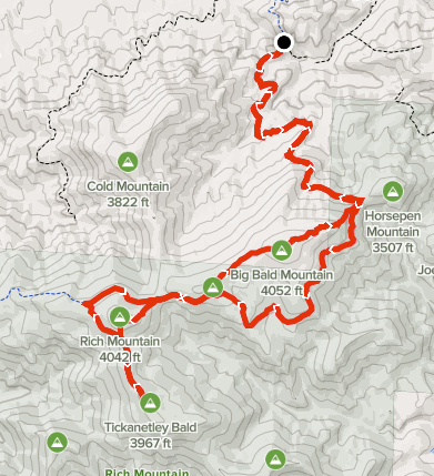
Summary
Distance: 13.1 miles
Elevation gain: 2,830 feet
Type: Out and Back
Trailhead: Pull off on dirt road (FS 338), passenger car accessible. (map)
Knocked out three more peaks on the GA 4000 Challenge today. One aspect of the Challenge that I really enjoy is exploring new areas, especially when you come across intriguing things, and this hike was did just that. Two things stand out as needing possible future investigation. First, there is Native American history in the area. There are signs on Big Bald Mountain warning people to leave artifacts alone. Also, we came across what is likely a “trail tree” along the route from Rich Mountain to Tickanentley Bald. Read more about trail trees at Mountain Stewards The other cool thing was a trail leading off the dirt road. I can’t find any information, so may need to re-visit the area and just see where it goes.
AllTrails map here.
The hike was a mix of dirt Forest Service (FS) road, abandoned roads, and bushwhacking. We parked on FS 338 and where we parked was about as far as a non-4 wheel drive and high clearance vehicle could go.
We stayed on FS 338 for about 5.5 miles to the saddle between Little Bald Mountain and Rich mountain. At about 4.6 miles from our starting point, we saw an old trail heading south along a spur. There was an old carsonite sign, but it was clear that the trail did not see much, if any, use. Might be an interesting day to hike that trail to see where it goes.
We we expecting some sort of trail heading from the saddle to Rich Mountain summit. The AllTrails map shows it, as do other sources. However, we could not find any sign of a trail, so we bushwhacked up the spur. The saddle was pretty thick with vegetation, but once we started up, the bushwhack wasn’t that bad. There’s an old chimney near Rich Mtn summit.
From Rich Mtn, we bushwhacked down a spur to a wide saddle between Rich and Tickanetley. Here, we found an abandoned road that made travel easy, and the path to Tickanetley showed some sign of use. We didn’t find an obvious summit. The rock in the photo was the highest point as far as we could tell.

Tickanetley Bald 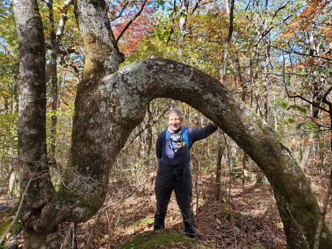
Possible trail tree
We left Tickanetley by backtracking on the old road, and kept on the road all the way back to FS 338 — no need to climb Rich again. After about a mile, we turned left onto a FS road that led towards Big Bald Mountain, our final peak of the day. This road led through two fields / wildlife openings. Both of these had signs warning that artifacts should not be disturbed. Once past the second field, it was a straight forward bushwhack to the summit. Look for a large tree, there is a SOTA marker for amateur radio enthusiasts on the tree.
We left Big Bald by bushwhacking east-north east along a spur back to FS 338. Briers were worse along this spur and we needed to carefully pick our way through which made for a slower descent.
