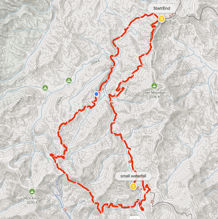
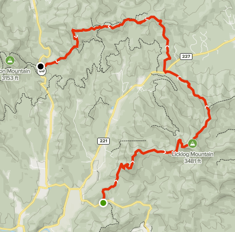
Benton MacKaye Trail Dyer Gap to Watson Gap

Summary
Distance: 12.1 miles
Elevation gain: 1,970 feet
Type: Loop
Trailhead: Watson Gap. Dirt road, passenger car accessible (map)
AllTrails map (here)

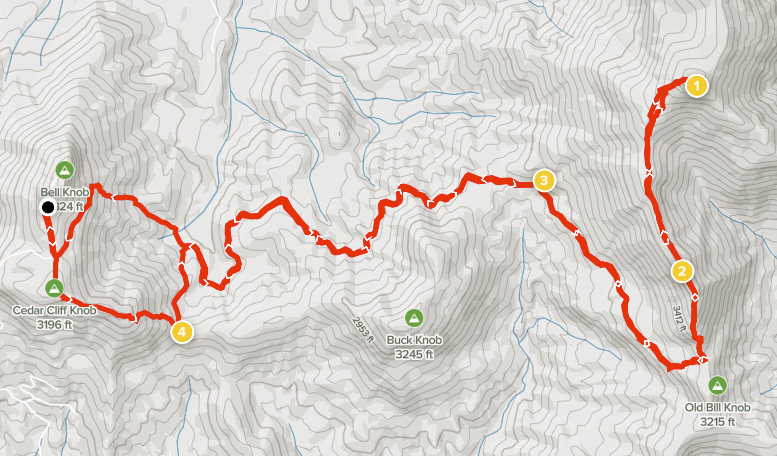
We wanted to finish this part of the Benton MacKaye Trail (BMT), which is only 4.5 miles, to set up a 20 mile BMT backpacking trip that will take us to the Ocoee River in Tennessee. So, we put together a loop hike that used the South Fork Trail and the Pinhoti Trail as well as about 4 miles of Forest Service roads.

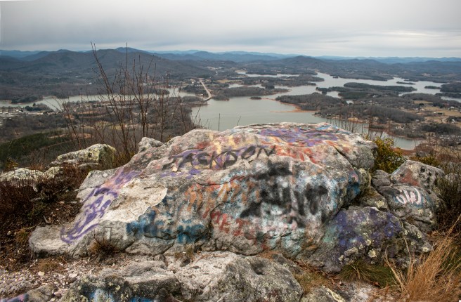
Overall, we both enjoyed the hike. It was a beautiful sunny Spring day, wildflowers were great, we found an intriguing historical marker, there are nice waterfalls on the South Fork of Jacks River, and we even took a quick dip in the river to cool off. Another plus is that we saw very few other people on the trail — a group of 3 horseback riders on Pinhoti, a group of 3 hikers on BMT near Dyer Gap, and a single hiker on South Fork.

But, you need to balance that against the rest of the hike. The Forest Service roads were pretty lightly traveled, but there was an occasional car or truck that passed. I think the biggest consideration about our loop is that the South Fork Trail and Pinhoti trails are old roads that see a fair amount of horse use. It was a dry day for our hike, but there were areas where the trails would have had a lot of mud on a wet day.

Continue reading “Benton MacKaye Trail Dyer Gap to Watson Gap”

Benton MacKaye Trail section 8

Summary
Distance: 13.3 miles
Elevation gain: 3,530 feet
Type: One way with shuttle
Start: Dirt road passenger car accessible. (map)
End: Dirt road passenger car accessible (map)
AllTrails map (here)

We’re working on hiking the Georgia part of the Benton MacKaye Trail (BMT) and hiked section 8 today from Bushy Head Gap to Dyer Gap. We had intended to hike this section as part of a backpacking trip, but life intervened and so we did a day hike instead. That meant the we left out the two and a half mile road walk from where the trail hits Boardtown Road to Bushy Head Gap. Anne was strong and determined to knock that out too, so we added those miles to the end of our day.

I think that I’ll remember two things about this hike. The first is the spectacular display of wildflowers, especially the trillium. The second is the really interesting old oak on top of Flat Top Mountain.

Continue reading “Benton MacKaye Trail section 8”

Benton MacKaye Section 1 and Appalachian Trail Loop

Summary
Distance: 9.7 miles
Elevation gain: 1,980 feet
Type: Loop
Trailhead: gravel road, passenger car accessible (map)
AllTrails map (here)

Today’s hike was unusual in that we were able to hike in a loop while completing a Benton MacKaye section. We started from the AT parking lot on FS 42. Springer Mountain is where the Appalachian Trail starts, so the parking lot was mostly full. There are two other good starting points. The “Alternate Start” on the map is a Benton MacKaye trailhead with a small parking area. Three Forks on FS 58 is also a good alternative. If you start at Three Forks, just park along the road. FS 42 and FS 58 are both dirt roads, but are passenger car accessible. The other road that climbs to Winding Stair Gap, FS 77, has gotten very rough and should probably be avoided in a car.

Our hike was great fun even though we didn’t include the Springer Mountain summit to avoid other people due to Covid concerns. There are two shorter loops possible as well. I think that the Southern loop that includes Owen’s Overlook is the better of the two due to the great views and the Springer Mountain summit coolness factor.

Continue reading “Benton MacKaye Section 1 and Appalachian Trail Loop”

Benton MacKaye Trail- Stanley Creek to Boardtown Rd

Summary
Distance: 12.55 miles
Elevation gain: 2,590 feet
Type: One way – shuttle
Start: Dirt road, passenger car accessible. (map)
End: Paved road, small dirt pull out. (map)
AllTrails map (here)

We’re still working on section hiking the Benton MacKaye Trail (BMT) northbound, and covered miles 40.8 to 53.5 today. Today was very interesting and varied, the first half of the day was on Forest Service land, while the second half was all private property. Given that it’s spring time in Georgia, we were also treated to spectacular wild flowers.

Continue reading “Benton MacKaye Trail- Stanley Creek to Boardtown Rd”

Eagle Mountain

Summary
Distance: 10.7 miles
Elevation gain: 2,966 feet
Type: Out and back
Trailhead: Paved lot, very steep road. (map)
AllTrails map (here)

We finished the Georgia 4000 Challenge with this hike, and it was an epic finish.

I think this was the most physically demanding peak bagging hike. It also traveled a very interesting route and had some great views. We chose to start our hike from Bell Knob, a public park near Hiawassee. The advantage of starting here is that the property is public, but the disadvantage is that it is on the top of a mountain. And, as it turned out, we underestimated the difficulty of the descent to get to the “normal” route. That route is not available to us because we do not have a high clearance four wheel drive.

Continue reading “Eagle Mountain”

Sassafras Knob, Mayapple Knob and Rattlesnake Knob

Summary
Distance: 5.5 miles — Egypt Gap to Rattlesnake Knob and back
Elevation gain: 1,700 feet
Type: Out and back
Trailhead: Private property
AllTrails map (here)

This was another day working on the Georgia 4000 Challenge, and these three peaks have eluded us for a while. The problem that we had was that my car could not make it up Bell Gap Rd to access the Forest Service land because the road has become deeply rutted. I was fortunate to find a way to access the area from private property with consent of the land owner. So, I’m describing the hike along the ridge between the peaks and not the entire hike.

These three peaks are numbers 29, 30, and 31 of the Challenge. Only one more to go now.

Continue reading “Sassafras Knob, Mayapple Knob and Rattlesnake Knob”

Benton MacKaye Sections 5 and 6a

Summary
Distance: 11.4 miles
Elevation gain: 2,090 feet
Type: One way, shuttle
Start: Dirt parking off paved road (map)
End: Dirt road, passenger car accessible. (map)
AllTrails map: here

This is my second day of working on my goal to section hike the Benton MacKaye trail from its start on Springer Mountain to the Tennessee state line. This hike continues from where we left off last time, Wilscot Gap on Hwy 60. As expected, the trail is well maintained and easy to follow. Heading out of the gap, the trail climbs steadily to the summit of Tipton Mountain where you can see glimpses of Lake Blue Ridge through the trees. After a descent into a saddle, the next climb is the to summit of Brawley Mountain which has an old fire tower. Eventually, the trail comes down to the Toccoa River, and then continues along paved roads to the Fall Creek Falls trailhead, the end on this hike.

Continue reading “Benton MacKaye Sections 5 and 6a”

Rich Knob and Hightower Bald

Summary
Distance: 9.3 miles
Elevation gain: 3,156 feet
Type: Out and back
Trailhead: Dirt road, passenger car accessible. (map)
AllTrails map

Today was a successful peak bagging day. After a cloudy start, we enjoyed a beautiful spring day in the mountains and climbed Rich Knob at 4,152 feet high and Hightower Bald at 4,588 feet. I think this may be my favorite peak bagging hike so far. The highlight of the day was walking along narrow ridges between Rich and Hightower. After summiting Hightower, we took a short side trip to find Montgomery Corner, a small, but interesting diversion in the Georgia/North Carolina border. Here’s an interesting article about Georgia’s northern border.

Continue reading “Rich Knob and Hightower Bald”

Benton MacKaye Sections 3 and 4

Summary
Distance: 11.1 miles
Elevation gain: 3,291 feet
Type: One way, shuttle
Start: Gravel pull off from paved road. (map)
End: Gravel pull off from paved road. (map)

The Benton MacKaye trail (https://bmta.org/) starts near the summit of Springer Mountain and extends around 300 miles to Davenport Gap on the northeast side of the Smoky Mountains. I plan to section hike the trail in Georgia, a distance of almost 90 miles. I’ll day hike some sections of the trail and backpack others. This was day one.

This was a fairly difficult hike with a lot of elevation change. The trail was easy to follow with its signature white diamond blazes and well used tread. AllTrails map here.

Benton MacKaye sections 3 and 4
Continue reading “Benton MacKaye Sections 3 and 4”

Bell Knob and Bell Gap

Summary
Distance: 3.9 miles
Elevation gain: 1,490 feet
Type: Exploratory
Trailhead: Paved lot, very steep and winding road. (map)

This hike was another attempt to find access to Eagle Mountain, one of the GA 4000 peaks. We attempted to drive up Bell Gap Road a few weeks ago, but it was way too rough for my car. Most of the area surrounding the Southern Nantahala Wilderness is private property. Bell Knob, near Hiawassee, is a public park that is famous for spectacular views and graffiti, and, I was hoping, would give access to Forest Service land.

Lake Chatuge from Bell Knob. Photo: Anne Ledbetter
Continue reading “Bell Knob and Bell Gap”